Why the Lowcountry Landscape Changes from Marsh to Pine
Lowcountry marsh to pine changes with elevation, soil, and saltwater. Learn what shapes each landscape and how to read the transition on the ground.
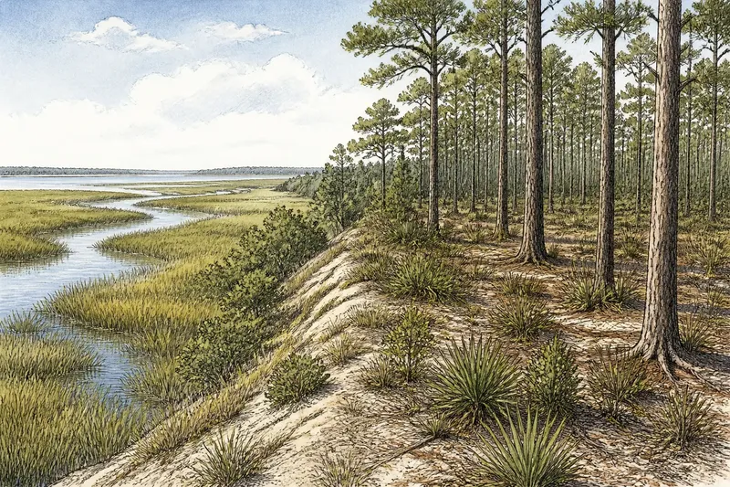
Why does Lowcountry marsh to pine change so abruptly along a road or field edge? Often, the ground rises only a little, but that small lift changes how long water stays, how much salt reaches the soil, and which plants can take hold. The result is not one landscape fading into another; it is a meeting of places with different rules.
What changes between marsh and pine flatwoods?
A marsh is a low, wet expanse where grasses and other water-tolerant plants grow in saturated soil. In coastal Lowcountry, tidal marshes are shaped by saltwater or brackish water moving through creeks and across broad, flat ground. Their open views, winding channels, and shifting edges make water the most visible feature.
Pine flatwoods, by contrast, are generally higher and drier, with pine trees rooted in sandy or otherwise well-drained ground. They may look level, but the soil and elevation keep them from being marsh. A sparse understory can include grasses, shrubs, and young trees; the exact mix depends on local conditions and land management.
The visual difference is plain: marsh presents a low, open horizon broken by water and grass, while flatwoods create a canopy and a more enclosed floor. Calling both “coastal land” is accurate but not especially useful, much as calling a bowl and its rim the same part of dinner misses the geography.
How does a small rise in the land alter the view?
Elevation determines how often a place is flooded and how long water remains after rain or a high tide. A marsh surface may be flooded on a regular tidal rhythm; a slightly higher patch can drain more readily and support plants that cannot tolerate persistent saltwater or saturated soil.
That modest change also affects what you see from the road. Along a causeway, the low ground may open into broad marsh on one side while the higher land carries pines on the other. The transition can be narrow, or it can pass through a band of shrubs and scattered trees. There is no single template: local slopes, drainage, and tidal connections shape the boundary.
Think of the ground as a shallow tray with a few low spots. Water settles in the lower areas first; the raised edges stay drier, even though they belong to the same larger landscape. The analogy is simple, but it captures why a small change in height can produce a conspicuous change in vegetation.
What role do tides and saltwater play?
Tides carry water into marshes through creeks and channels, and the salt content varies with the mix of seawater and freshwater. Salt-tolerant marsh plants can thrive in conditions that would stress many upland plants. The channels also move sediment and help shape the marsh’s branching pattern, so its distinctive lines are not merely decorative features.
Pine flatwoods are less directly shaped by routine tidal flooding. Their soils may still be influenced by a high water table, seasonal rain, or nearby coastal processes, but they do not generally share the daily exchange that defines a tidal marsh. That difference helps explain why the two habitats support visibly different plant communities even when they lie close together.
Where freshwater and saltwater mix, the transition can be especially varied. A creek may bring fresh water inland, while tidal water pushes salt farther up its course. Conditions can shift with rainfall, season, and local geography, so a map’s simple label may conceal several distinct plant zones.
Why do pine flatwoods have their own seasonal character?
Flatwoods are not simply dry forest. Their sandy soils can drain quickly at the surface while holding water at shallow depth, producing conditions that change with rain and season. Pines are adapted to this setting, but the understory can vary with soil, moisture, and the history of disturbance.
Fire has shaped many southeastern pine ecosystems. In some settings, periodic fire helps maintain open conditions and favors certain native plants; in others, fire may be absent or managed differently. The appearance of a particular stand depends on its site and stewardship, so a dense patch of shrubs is not enough to identify its history.
Seasonal shifts are legible in the understory as well as the trees. Wet periods can leave low spots soft or standing in water, while drier stretches expose sandy ground and leaf litter. The pines remain the defining structure, but the floor changes the scene around them.
How can you tell where the marsh edge ends?
Look for a change in both ground and vegetation rather than searching for a sharp line. Marsh grasses give way to shrubs or trees where flooding and salinity become less limiting; the edge may be irregular, interrupted by creeks, or altered by a ditch, road, or old embankment.
From a safe public viewpoint, note these clues:
- Water paths: Tidal creeks and channels point to areas that remain connected to the marsh.
- Plant form: Low, continuous grasses suggest marsh; woody shrubs and pine trunks indicate higher ground.
- Soil and footing: Wet, soft ground differs from the firmer sandy surface often found in flatwoods.
- Elevation changes: A road crown, bank, or natural rise can mark a shift in drainage.
- Salt exposure: Salt-tolerant plants near tidal water may give way to other vegetation farther inland.
These are field clues, not a substitute for a habitat map or local ecological knowledge. A roadside ditch can imitate a natural channel, and a planted pine stand can look unlike surrounding flatwoods. Observe from public access and avoid entering wetland or private land.
What questions help explain the marsh-to-pine transition?
Does every marsh edge lead directly into pine flatwoods?
No. The transition may pass through scrub, wet woodland, or other habitat, and some marsh edges meet developed land or open water instead. Local elevation and drainage determine what appears between the two.
Can pine trees grow in wet ground?
Some pines tolerate wetter conditions than others, and flatwoods can have a high water table or seasonally wet depressions. The presence of pines alone does not prove that a site is well drained.
Why does the marsh look different at high and low tide?
As water moves through the channels, more or less of the marsh surface and creek banks are exposed. The vegetation remains in place, but the visible balance between grass, mud, and water changes with the tide.
Can a road or ditch change the boundary?
Yes. Roads and drainage ditches can redirect water or interrupt its movement, which may alter local wetness and vegetation. The scale and effect depend on the site, so a visible boundary may reflect both natural landforms and human changes.
How should you read the landscape while traveling?
Watch for the sequence: open water, marsh grass, a low woody fringe, then pine trunks on firmer ground. The order may be compressed or rearranged, but noticing the changes in water, soil, and plant form makes the view more legible than treating every green expanse as the same scenery.
Say you are crossing a causeway and see cordgrass beside a tidal creek, then shrubs and pines beyond a slight rise. You can infer that the creek-side ground experiences more frequent saltwater flooding and that the higher ground drains differently; you cannot infer the exact soil, ownership, or management history from the view alone. That is a useful distinction between reading a landscape and inventing its backstory.
Lowcountry marsh to pine is best understood as a change in conditions, not a change in regional identity. Tides, salt, freshwater, soil, and small differences in height shape separate habitats close enough to share a horizon. Once you notice those forces, the boundary stops looking arbitrary: the marsh follows the water, and the pines begin where the ground can hold them.